


.
Stanford's Library Map of London and its Suburbs")
Lot 95
Stanford (Edward).
Stanford's Library Map of London and its Suburbs
Hammer Price: £700
Description
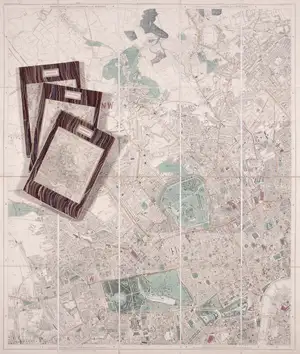
Stanford (Edward) Stanford's Library Map of London and its Suburbs, large engraved map with hand-colouring, on four sheets, each dissected and linen-backed with marbled ends and index map labels, each sheet measuring c.970 x 850 mm., some light offsetting, minor browning and surface dirt, presented in morocco slip-case, worn, 1886.
⁂ According to Hyde, this was the first 'thorough-going survey of the Metropolis since Greenwood's in 1824-26'.
Description
Stanford (Edward) Stanford's Library Map of London and its Suburbs, large engraved map with hand-colouring, on four sheets, each dissected and linen-backed with marbled ends and index map labels, each sheet measuring c.970 x 850 mm., some light offsetting, minor browning and surface dirt, presented in morocco slip-case, worn, 1886.
⁂ According to Hyde, this was the first 'thorough-going survey of the Metropolis since Greenwood's in 1824-26'.
 Newsletter Signup
Keyword Alerts
You can now save your preferences to receive emails, or create a free lite account which gives you more features.
Would you like to receive personalised keyword alerts when new catalogues go live. If so, please indicate these below
Set a password to save your keyword alerts
Passwords are a minimum of 7 characters and must include an upper case letter, a lower case letter, a number and a special character.