


![134London.- Lewis (Samuel) A Plan of London and its Environs, Shewing the Boundaries of the Cities of London and Westminster , [circa 1850].](https://am-s3-bucket-assets.s3.eu-west-2.amazonaws.com/forum/prod/lot_images/xlarge/cf4295d7-9a90-ee11-b864-d4548b6f1f2f/b34c146f-8091-ee11-817a-6045bdcfd69d.webp "134London.- Lewis (Samuel) A Plan of London and its Environs, Shewing the Boundaries of the Cities of London and Westminster , [circa 1850].")
Lot 134
London.- Lewis (Samuel) A Plan of London and its Environs, Shewing the Boundaries of the Cities of London and Westminster , [circa 1850].
Hammer Price: £750
Description
London.- Lewis (Samuel) A Plan of London and its Environs, Shewing the Boundaries of the Cities of London and Westminster, showing from Stoke Newington to Dulwich, and from Hammersmith to Greenwich, with some railway lines included, and showing Victoria Park, decoratively lettered title and compass rose upper right, within an ornate border, engraved map by I. Dower, with early hand-colouring, 960 x 1140 mm. (37 3/4 x 44 7/8 in), dissected and mounted on linen, overall light even browning, folding into original red morocco gilt boards, rubbed, spine splitting, worn, [circa 1850].
Related Lots
Back To Auction Catalogue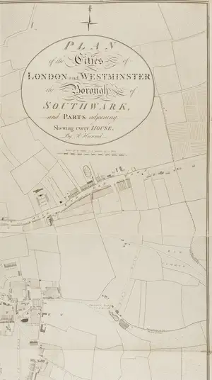


 Newsletter Signup
Keyword Alerts
You can now save your preferences to receive emails, or create a free lite account which gives you more features.
Would you like to receive personalised keyword alerts when new catalogues go live. If so, please indicate these below
Set a password to save your keyword alerts
Passwords are a minimum of 7 characters and must include an upper case letter, a lower case letter, a number and a special character.