Lot 50
Cary (John) Cary's Improved Map of England and Wales with a considerable portion of Scotland, planned upon a scale of two statute miles to one inch, 1832.
Hammer Price: £850
Description
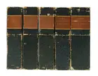
Cary (John) Cary's Improved Map of England and Wales with a considerable portion of Scotland, planned upon a scale of two statute miles to one inch, monumental survey map, complete in 65 sections, with calligraphic title, index map sheet, and Explanation key sheet, engravings with bright original hand-colouring, each map section approx. 530 x 650 mm (20 7/8 x 25 1/2 in), dissected and mounted on light-brown coloured linen, some offsetting and occasional spotting and browning throughout, minor surface dirt, each folding with printed label of Parisian publisher 'Ch. Piquet', small red ink collector's stamp 'Bibliothèque St. [?] Grieg' to many, and vellum tab to all, the Index map with heavy toning, presented in five uniform blue-green marbled slip-off cases, each with gilt red label to spine lettered in French, rubbed and worn, 4to, 1832 (5)


