

 London and its Environs, 1847; and 3 other folding maps of London, 1787-1869 (3)
")
Lot 216
Davies (Benjamin Rees) London and its Environs, 1847; and 3 other folding maps of London, 1787-1869 (3)
Hammer Price: £900
Description
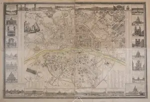
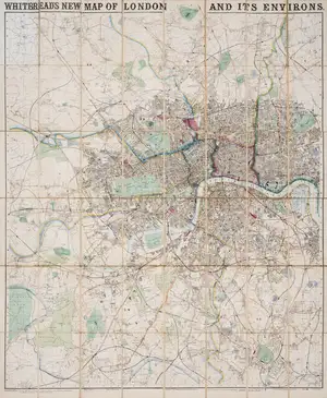
Davies (Benjamin Rees) London and its Environs, Containing the Boundaries of the Metropolitan Boroughs, the different Railroads & Stations, The New Cemetaries, Roads, Docks, Canals, and all the modern improvements, lithograph with vibrant original hand-colouring, 570 x 725 mm (22 1/2 x 28 1/2 in), dissected and mounted on linen, minor surface dirt, folding with marbled ends into original dark brown boards, gilt, spine split with upper cover almost detached, 8vo, [Howgego 404 (1)], C.F.Cheffins, 1847 § Cary (G. & J.) Cary's Map of the Country 12 Miles Round London, engraving with fine original hand-colouring, 590 x 723 mm (23 1/4 x 28 1/2 in), dissected and mounted on linen, old signs of splitting to platemark at lower centre, well outside the map, now secure without any loss, folding with green endpanels into slipcase with publisher's printed label to upper cover, 8vo, [?Not in Howgego], 1828; together with Wyld's New Plan of London and its Vicinity, engraved map with vibrant hand-colouring, 790 x 1160 mm (31 x 45 3/4 in), dissected and mounted on linen, minor spotting and surface dirt, folding with publisher's printed label to endpanel, folding into cloth boards, publisher's printed label to upper cover, 8vo, 1869; together with 'Andrew's New and Accurate Map of the Country Twenty-five miles round London...' [Howgego 167], 1787 (4)
Description
Davies (Benjamin Rees) London and its Environs, Containing the Boundaries of the Metropolitan Boroughs, the different Railroads & Stations, The New Cemetaries, Roads, Docks, Canals, and all the modern improvements, lithograph with vibrant original hand-colouring, 570 x 725 mm (22 1/2 x 28 1/2 in), dissected and mounted on linen, minor surface dirt, folding with marbled ends into original dark brown boards, gilt, spine split with upper cover almost detached, 8vo, [Howgego 404 (1)], C.F.Cheffins, 1847 § Cary (G. & J.) Cary's Map of the Country 12 Miles Round London, engraving with fine original hand-colouring, 590 x 723 mm (23 1/4 x 28 1/2 in), dissected and mounted on linen, old signs of splitting to platemark at lower centre, well outside the map, now secure without any loss, folding with green endpanels into slipcase with publisher's printed label to upper cover, 8vo, [?Not in Howgego], 1828; together with Wyld's New Plan of London and its Vicinity, engraved map with vibrant hand-colouring, 790 x 1160 mm (31 x 45 3/4 in), dissected and mounted on linen, minor spotting and surface dirt, folding with publisher's printed label to endpanel, folding into cloth boards, publisher's printed label to upper cover, 8vo, 1869; together with 'Andrew's New and Accurate Map of the Country Twenty-five miles round London...' [Howgego 167], 1787 (4)
Related Lots
Back To Auction Catalogue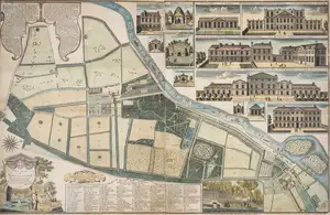
 Newsletter Signup
Keyword Alerts
You can now save your preferences to receive emails, or create a free lite account which gives you more features.
Would you like to receive personalised keyword alerts when new catalogues go live. If so, please indicate these below
Set a password to save your keyword alerts
Passwords are a minimum of 7 characters and must include an upper case letter, a lower case letter, a number and a special character.